The Tetepare Conservation Program
 Tetepare Island is conserved and managed by TDA. The entire island is protected from commercial resource extraction but low levels of artisanal resource use by local villagers are allowed in some areas. Additionally, the TDA established a 13km-long Marine Protected Area (MPA) in 2003 which is a permanent no-take zone. This closed area protects Tetepare’s reefs, lagoons and coastal waters from all harvesting from the western tip of the island on Mbo Point at S 8º 42.22' E 157º 26.36' to the eastern edge of Soe Island along the southern weather coast S 8º 43.62', E 154º 47.34'. The protected area also includes the land area from the low water mark to 500m inland and forms the largest contiguous Marine Protected Area (MPA) in the Solomon Islands.
TDA employs rangers to patrol the island and the MPA. Signs have been installed and are maintained at each end of the MPA. The aim of this MPA is to provide a protected nursery ground for marine species and preserves in its natural state the area of Tetepare's pristine ecosystem adjacent to the research station and ecolodge. Monitoring occurs inside and outside the MPA and results used to set harvesting limits over the remainder of the island.
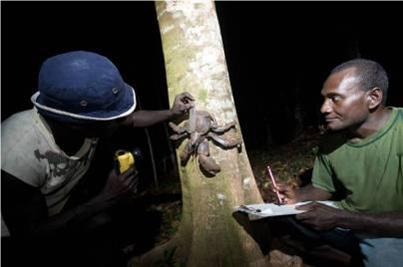
TDA runs numerous monitoring programs to inform conservation management both on and offshore from Tetepare. Monitoring programs have been established for turtles, seagrass, coconut crabs, reef check, forest, fish and trochus. Click here to learn more about these research and monitoring programs or download a copy of the latest research and monitoring report